“Final Cirrus Flight”
February 23, 2007“Longest Flight EVAR”
February 26, 2007Lancair-school is pretty fun! My class poses in front of my new bird.
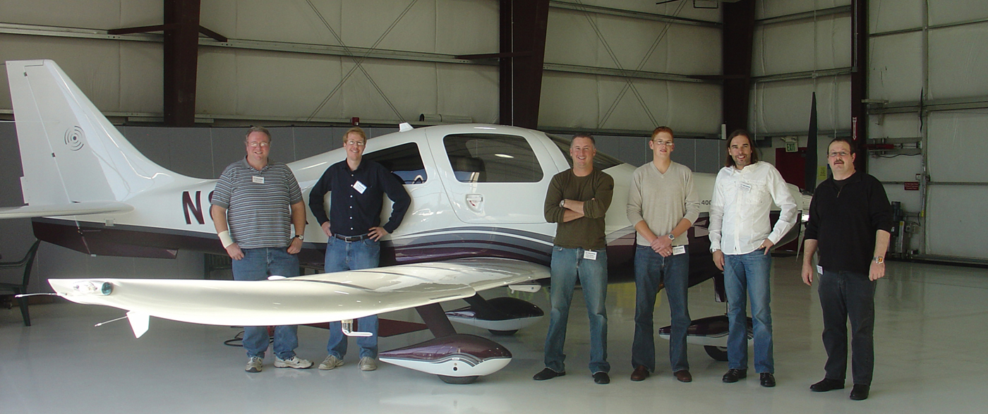
The Lancair (oh… I am supposed to call them “Columbia Aircraft Manufacturing”) guys are moving about 1 plane per business day. Class lasts a week. So you get to go through school with about 5 other guys getting Lancairs… we had a for-hire instructor, me, a lo-time successful business-man there with his own personal kid-instructor, and 2 guys from Germany grabbing a Lancair (one of them also switching from a Cirrus!). Can you tell who is who in the picture above? We also had a really good (and fun!) instructor named Eddie who looked just exactly like Hugh Jackman, the Wolf-Man from the X-Men movie!
OK after a whopping THREE flights with an Eddie in 842X (too few, since there is so much to learn, the plane offers so much to enjoy, and Eddis is so fun to fly with), it was time for cross-country trip #1, fittingly from Bend, Oregon (the Lancair’s birth-place) to Precision Flight Controls in Sacramento, California, (one of my checkbook’s re-supply-points) to work on an FAA-certified Beech Baron simulator for Japan Air Lines.
It was a cold but clear day in Bend, Oregon, as I started up 842X and taxied out of the Lancair factory, watching my wings as I pulled past maybe 2 dozen speedy-birds on the ramp there. Bend is quite literally BUZZING with Lancairs… they are all over the place there. Anyway, taxi to the end of the runway at this small, un-controlled field, and time to go!
Take-off in a Columbia-400 is a pretty cool experience: There is a turbo lag, so as you add power, at first the engine sort of “growls”, and you think “OK, this performance is all right, but not that great”, and then the turbo kicks in and the prop and engine sound like this: “RRREEEYYYOOOOOWWWW!!!!” and you are pushed back in your seat as the turbo spins up and the power starts falling on you like a waterfall. The landing gear is pretty springy and soft, so the heavy bird rocks and rolls down any imperfectly-paved runway like a powerboat on the waves, and in a few moments you are racing at around 100 miles per hour down the runway! It takes a hefty pull back on the stick to raise big heavy engine and prop and the plane soon gathers 110 knots, it’s best rate-of climb speed. This results in about 1500 feet per minute when the plane is a bit heavy. Now here is where it gets interesting: The plane is still climbing at 1500 feet per minute coming through 18,000 feet. That’s because of the turbo: The turbo is spinning madly (150,000 rpm!) to keep full power coming out of that engine even at 18,000 feet. This power comes at a price, though: a full-power fuel flow of 41 gallons per hour! This is truly like the afterburner on a fighter: Gulping fuel at an insane rate to deliver 100% power all the way to 18,000 feet while keeping the engine cool. Climbing to 18,000 feet uses about 9 gallons of gas: That’s half the fuel capacity of a large car, gone in 12 minutes. Then again, when done, you are 3 miles straight up, going 220 miles per hour.
Once to 17,500 feet (about 12 minutes) I pulled the throttle, prop rpm, and mixture way back to 65% power, lean-of-peak. This results in a 15 gallon-per-hour fuel flow and 190 knots (220 miles per hour). Now, with 106 gallons in the tanks, you see that 15 gallons per hour can have you flying, in theory, for 6 hours if you allow 8 gallons to climb and a 30-minute reserve. 6 hours at 220 miles per hour… do the math on the ground you can cover. The Garmin 1000 on the panel draws a circle showing the range of the craft, and when you zoom out to a National scale you can see that taking off from Bend, Oregon, in a Lancair that Canada, Alaska, Texas, and Mexico are all within non-stop range… and that is neglecting the wind, which can favor you on the order of 100 knots in the jetstream.
Below, the dashed green line shows the range with a 45 minute reserve (reached in 5 hours, 2 minutes) and the solid green line shows the total range. Alaska and southern Mexico are both in range at once.
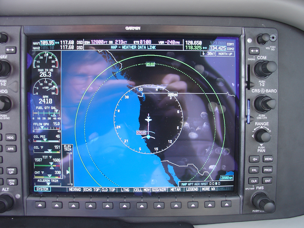
Once you level off at 17,000 feet, you see the time from Oregon to Sacramento: One hour twenty-one minutes. (The flight up was 2.5 hours in the Cirrus).
Why the huge advantage? Well, the reasons are 3-fold:
1: The Lancair CLIMBS so much faster. It quickly hops to it’s higher-speed cruise, while the Cirrus would still be working to climb.
2: The Lancair GOES faster… running really gently (like I do) it’s 190 knots compared to 160.
3: The Lancair goes HIGHER (the Cirrus cannot hit 17,500), so it can climb more quickly into favorable winds (when they are favorable, which is half the time).
Now, with 1:21 left on the clock to traverse the Pacific Northwest, it was time to see what the cockpit instrumentation had to offer. An Autopilot that can climb, cruise, descend, and fly a full GPS or ILS approach for you. Got it. EFIS display that shows the plane’s speed, altitude, vertical speed, orientation, and all that jazz. Got it. EFIS display that shows everything going on in the multiple batteries, generators, and electrical buses, and everything happening in the engine down to the temperature of the combustion in each cylinder and each turbo-charger. Got it. EFIS display that shows you a map with your plane creeping across it, showing where you are, where you are going, when you will get there, when to start your descent, and what runways, frequencies, and traffic patterns await you when you get there. Got it. A map that shows all terrain, airports, air-space, TFR’s, and even has the terrain turn yellow (and then red!) if you get too close to smacking it. Got it.
All this I saw in Lancair training, but here is what got wild: The XM-RADIO music and WEATHER. First things first: Switch the AUXILIARY page on the secondary EFIS display, XM-sub-group, all categories selected. Ah yes. There it is: hundreds of XM-radio channels with the all-important techno channels “Escape”, “The Move”, “Beats per Minute”, and “The System”. The engine is so quiet, the airframe so rigid and sound-deadening, the interior so leather and sound-absorbing, the door-seals so tight (they are active-inflateable), and the Bose Aviation-X active noise canceling headsets so perfect (you get 4 with the plane) that you actually have a decent environment to listen to music, and a decent sound system to play it. In an airplane. As well, the music auto-mutes, smoothly, whenever ATC says anything, so the music does not hurt air-traffic control communications. So you are humming along quietly in a BMW-class cockpit at 220 miles per hour, at 17,500 feet, with fuel for 6 hours, the majority of the North-American continent within non-stop range, with “Vibe-all-Styles” on “The Move” cranked to the max. Not too bad.
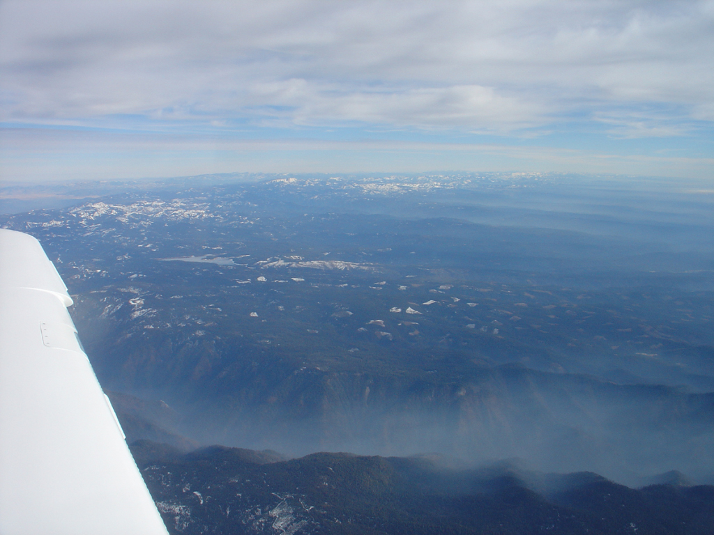
Did I mention the Rocky mountains, foggy valleys, misty lower cloud and fog-layers shrouding the craggy valleys and forests 3 miles below, and tall, snowy mountains poking up into the 100-mile visibility in crystal-clear blue winter air, all rolling along outside the cockpit window? Anyway, there’s that, too.
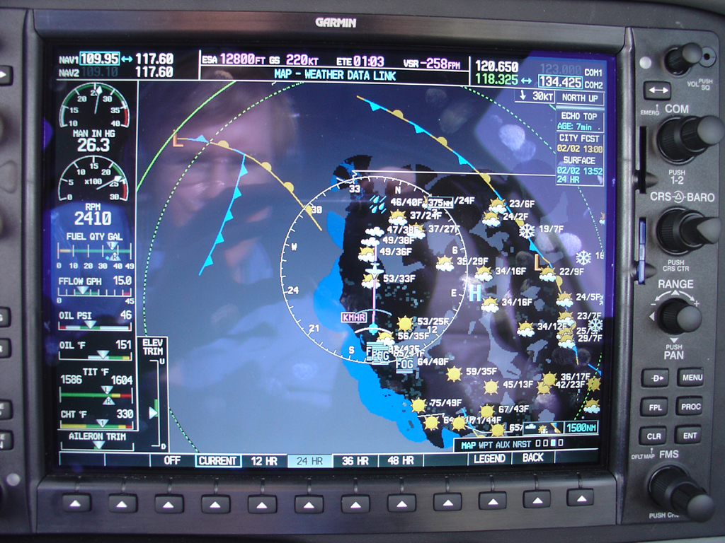
Now it was time to play with weather options. This is what blows your mind. On your map, you can see the freezing levels across your entire area of the country, out to 1000 miles. This is needed to see where ice can form. Then turn on the satellite-image, and see the cloud cover for your entire region of the country. Then turn on echo-tops, and see how HIGH these clouds go, while they are still 1,000 miles away from you. Then turn on the weather synopsis chart to see all the fronts, clouds, rain, and fog in the country. Then hit the ’12 hour’ hour button to see what the weather will be 12 hours in the future. Or the ’24 hour’ or ’36 hour’ buttons to see what the weather will be like tomorrow, or moving into the day after that. Or move a little mouse-cursor over any airport and hit the “WX” button and see the current weather at that airport, with ceiling, visibility, barometric pressure, and wind… even if the airport is 1,000 miles away. Then hit the WIND button and you see THE ENTIRE WIND FLOW-FIELD FOR THE ENTIRE UNITED STATES AT 3,000 FEET. This shows hundreds of little arrows, each of which represents the wind at some spot over the country at 3,000 feet. Then hit the “6,000” button to see the wind at 6,000 feet, nation-wide. Or 9,000 feet. Or 12,000. Or 15,000. Here is how it works: You look at the various different altitudes from surface to 18,000 feet, each with a single button-press, observing the national wind-flow patterns at each altitude to see what altitude gives you the most tail-wind along your route. Then you turn a single knob on the autopilot to set that altitude and the plane takes you there. While you sit and watch. Some may say that headwinds are common, but since the wind often changes direction with altitude, and in this plane you can see all wind, at all altitude, you can actually get a tailwind more than 50% of the time in a Lancair: You just go where the wind is at your back… surface to 25,000 is available.
So, cruising in this plane, you have total comfort, amazing quiet, perfect XM radio reception and music, while the autopilot whisks you along across the nation and you poke through the weather pages to see everything going on in your quadrant of the Country. Well, 1:21 was FAR too short a flight (!), but by the time I had perused the weather and XM techno channels, the secondary EFIS was telling me that it was 9 minutes until time to descend. A quick “Pop-Up” IFR to get my down thru the misty low-altitudes, and I let the plane fly the ILS for me while I watched. Paste it on (smooth landings are pretty easy in this plane IF YOU COME IN WITH PLENTY OF SPEED and just sort of ‘roll’ it onto the ground in a very shallow descent that levels off to almost nothing right near the end) and taxi to the FBO at Mather field.. now it’s time to get back to work!