“428X”
November 26, 2008“Shawano –> Columbia”
February 26, 2009Oshkosh 2008 (December 2008)
OK it was time to take 428X (successor to 842X, successor to 248X, all identical columbia-400’s right down to the color options) to Green Bay, Wisconsin, to see a customer.
The trip was only 820 miles… nothing but a nice jog for a Columbia-400 (now technically called a CESSNA-400, since Cessna bought the company), BUT, we had a 70-knot headwind at normal cruise altitude of 17,000 feet. And this was in the winter, where icing is common. And there was a cold front moving thru with clouds, snow, and freezing rain. And the temperature was zero at the surface in the Chicago to Green Bay area. And I would overfly Lake Michigan, in freezing weather, at night, in the middle of the winter over Chicago, in a 70-knot headwind.
Windy City, indeed!
Now, when most people hear ’70 knot headwind at cruise altitude’, they automatically say “Then we will fly lower!”
This is not QUITE the best idea, though, always, and it really depends on the plane. Remember, the Columbia-400 is a turbocharged airplane: It goes fastest, by far, above 15,000 feet. This is where the air drag goes way DOWN, but the engine keeps running just fine with the dual turbos packing in plenty of air, and the dual intercoolers keeping the temperatures down in the process. This airplane is significantly faster, for the same fuel flow, at 15,000 feet than it is at sea level. Thanks to the lower drag at high altitude, it is really quite amazing how much headwind it is acceptable to have AND STILL CLIMB HIGHER FOR BEST GAS MILEAGE. Now, exactly HOW much headwind is too much? Exactly WHAT is the best altitude to climb to? No GA pilots ever seem to know the answer to this question! I am better equipped than almost anyone else to answer this, though, because I have an iPhone! And it has X-Planner (the flight-planner I wrote) on it. X-Planner lets you enter the cruise speeds and fuel flows of your airplane at all altitudes, and the wind speed and direction at all altitudes, and your departure and arrival airports, and X-Planner will then tell you the exact time and fuel flow for every altitude enroute! As well, it will quickly tell you WHAT altitude gives you the best blend of speed and efficiency for that trip, on that day.
Now, there are plenty of flight-planners out there, but they all run ON PERSONAL COMPUTERS! ARGH! USELESS! Many times when we fly, we are leaving from the middle of who-knows-where with no access to our personal computer… it may be a desktop at home, or a laptop that is somewhere else. As well, even if you travel with a laptop, it may take a while to dig out of the back of the airplane, and it certainly takes a while to boot up and run! Furthermore: Remember that laptop hard-drives run with the hard drive head floating on cushion of air.. THEY CAN ONLY BE USED BELOW 8,500 FEET! If you run your laptop above 8,500 feet in an unpressurized airplane, you are asking to crash your hard drive! This prohibits you from using the laptop based on updated winds aloft in-flight in a high-performance airplane.
So, the existing PC-based flight-planners are typically useless since they are on a PC somewhere where you are NOT, or hidden away in a bag in the back of the airplane on a big, clumsy, slow-to-boot laptop, and can NOT typically be used in flight, which is a problem for longer flights like South Carolina to Green Bay Wisconsin in up to 70 knot headwind.
The iPhone, on the other hand, is always with you (fits in your breast pocket!) boots almost instantly, has no hard drive to crash, can be used at any altitude, and is always with you at the ready. THIS is the perfect platform for a flight planner! Just touch the X-Planner button on the iPhone (if you have an iPhone and X-Planner!) and you can dial in the conditions for the flight no matter where you are, at a moments notice, even if starting your flight from the middle of nowhere, and even if you want to update your plans enroute! (Note: Since I have put X-Planner on the AppStore, I have sold about 10 copies, and gotten a grand total of about 3 reviews, 2 of them negative. This is because TWO OUT OF THOSE THREE REVIEWERS ARE IDIOTS… one of which was too stupid to see the features that were right there in front of him, claiming that the planner does NOT do things that it actually in fact DOES.)
Ahem! Anyway! Back to the story! With 820 miles in front of me and headwinds varying from 20 knots at the surface to 70 knots at 15,000 ft, what would be the best altitude for my trip? I dialed the trip into X-Planner and found that yes, in this case, the wind was SOOO string up high, that even 428X was better off flying this one at 6,000 feet. (Imagine: 6,000 feet from South Carolina to Wisconsin in one bound, straight-line, no stopping! I could get a continuous view of the terrain from South Carolina to Wisconsin without interruption, the autopilot taking me just over the ground the entire way… more like a high-speed TRAIN-RIDE than an airplane flight!) (Jets can NOT do this because they use too much fuel down low.. most lo-performance prop planes can NOT do this because they do not have this kind of speed and range.. only the Cessna-400 can make this kind of long, low-altitude, his-peed trip on a reasonable fuel budget, because of it’s low-drag shape to minimize drag in thick, low-altitude air, efficient engine to minimize fuel-burn in the thick, low-altitude air, and moderate wing-loading to give minimum drag in high air density of low altitude).
With my trip dialed into X-Planner on my iPhone and 6,000 ft confirmed as the best altitude, I quickly entered the weight of myself, full fuel, and my various suitcases and computers for the job into X-Planner and saw that my weight and balance were perfect as well. The temperature was a balmy, comfortable 70-degree sultry afternoon in South Carolina as I got into the seat of 428X and closed the cabin door… I knew that the next time I opened that door, I would be half a country away, opening it into a zero-degree blustery winds with a negative-20-degree windchill at night in Green Bay.
Ah, Airplanes!
God, I love airplanes.
ANYHOO, with the door closed and the engine loping lazily to life with a nice idle and whiff-whiff-whiff sound of the prop, I taxied out to the runway at KCAE and was off with 102 gallons on board, autopilot steering me to KGRB within a few moments of liftoff. There is very, very little inefficiency in the operation of a Cessna-400.. the plane can take off and be on-course within 30 seconds of leaving the pavement, take a perfectly straight-line, autopilot-driven course to any destination with the most efficient type of engine (internal-combustion-reciprocating) running lean of peak to use minimum fuel, and turn a 1-mile final to land at the destination, with no other drama or side-track… it really comes as close as I can imagine to perfect travel, since it does this most-efficient trip while being stunningly comfortable and quiet inside, other than the sound of techno from the XM radio in the BOSE-ANR headsets as the autopilot takes you to whatever 4-digit airport identifier you just entered.
Now, flying along at 6,000 feet is nice because it lets you see the countryside, but it does have it’s drawbacks, other than going a bit slower: You have to watch out for mountains, towers, and airspace around airports. Luckily, the plane tells you about ALL of these things.. the terrain on the MAP turns YELLOW if it is within 1000 feet of you vertically, and RED if it is within 100 feet of you vertically, so a 1-second glance at the map will tell you if you are too close for comfort to any terrain. The MAP draws an OBSTACLES (towers or buildings) in yellow or red if they are too close, as well. Furthermore, the plane will mute my techno and shout ‘Terrain! Terrain!’ or ‘Obstacle! Obstacle!’ if I ignore the color-coding and get too close. As well, a little WARNING message will flash on the primary flight display if i am within 5 or 10 minutes of entering anybody’s airspace. With the airplane looking out for all possible collisions, it is a lot easier to sit back and relax as it whisks you along to your destination, even with the thicket of mountains, towers, and airspace that clutters the low altitudes.
ANYHOO, off we went (‘we’ means me and 428x) over the Appalachains, up through North Carolina, Tennessee, Kentucky, Indiana, and here is where things started to get interesting. You may remember what I said about crossing lake Michigan, and the temperature being zero degrees (celsius!) at the surface, and the freezing rain and snow. You do NOT want to be low over lake Michigan, at night, picking up ice and unable to hold altitude as ice forms on your plane and it is zero outside. Really. This was NOT an option. Now, you probably know that the HIGHER you go, the COLDER it gets.. and if you go high enough, it gets SO cold that ice can NOT form on the plane because it is so cold that all moisture in the air is ALREADY in ice form.. so all it does is bounce off of your plane, not stick to it and freeze. So, my solution to the freezing-clouds-over-the-lak problem was quite simple: File IFR, pour on the coals, and climb to 16,000 feet, where it was SO cold that ice could NOT form on the plane. As well, with all that altitude, I could GLIDE to the shore for MOST parts of the over-lake journey if the engine quit.
Now, here is where I wish my camera would work, handling lo-light conditions. I was over Lake Michigan at 16,000 feet at night, with dark cotton puffs of clouds spreading out for many miles below me.. but some of the cotton was glowing dull yellow! These were the lights of Chicago lighting up the undercast.. Soon, there were dark clouds ABOVE me, and the freezing snow or hail was lit up on my strobes. Red rain seemed to streak by on my left (red form the left nav-light) and green rain seemed to streak by on my right (hail o snow lit up by the right nav-light) and all of the hail or snow was lit up for an instant, every second, from the strobes. It was totally surreal, and you could have no sense of scale at all.. are those dark clouds overhead huge and far away, or small and close? Is Chicago 1 mile away or 50? You just could not tell. Everything was so dark, with just the slightest bit of light from Chicago, or from 428X itself, that you just got the barest suggestion of cloud, or snow, or atmosphere, or water. The only thing I could be sure of was that certain mechanical failures would end my life that night… the great freezing lake below would claim me if I lost power beyond gliding range… and with total dis-orientation from the low visibility and strange beckoning lights amongst vast random clouds, the instruments really needed to keep throwing the heat as well.
For safety’s sake, in the future, I think I will plan my routes to NOT go OVER the Great Lake, but rather AROUND it.
Soon after passing north of Chicago and Lake Michigan, I started my descent into Green Bay.. after taking off 5 hours earlier in the balmy South Carolina afternoon, it was a little bit odd to be slipping and sliding on slippery white snow lit up by the landing light. When I shut down and opened the door into the freezing Green Bay evening… sure enough… that minus-20 windchill instantly entering the cockpit gave me he wake-up call that simple text and number can NOT demonstrate: I would NOT have survived going down in that lake.
![]()
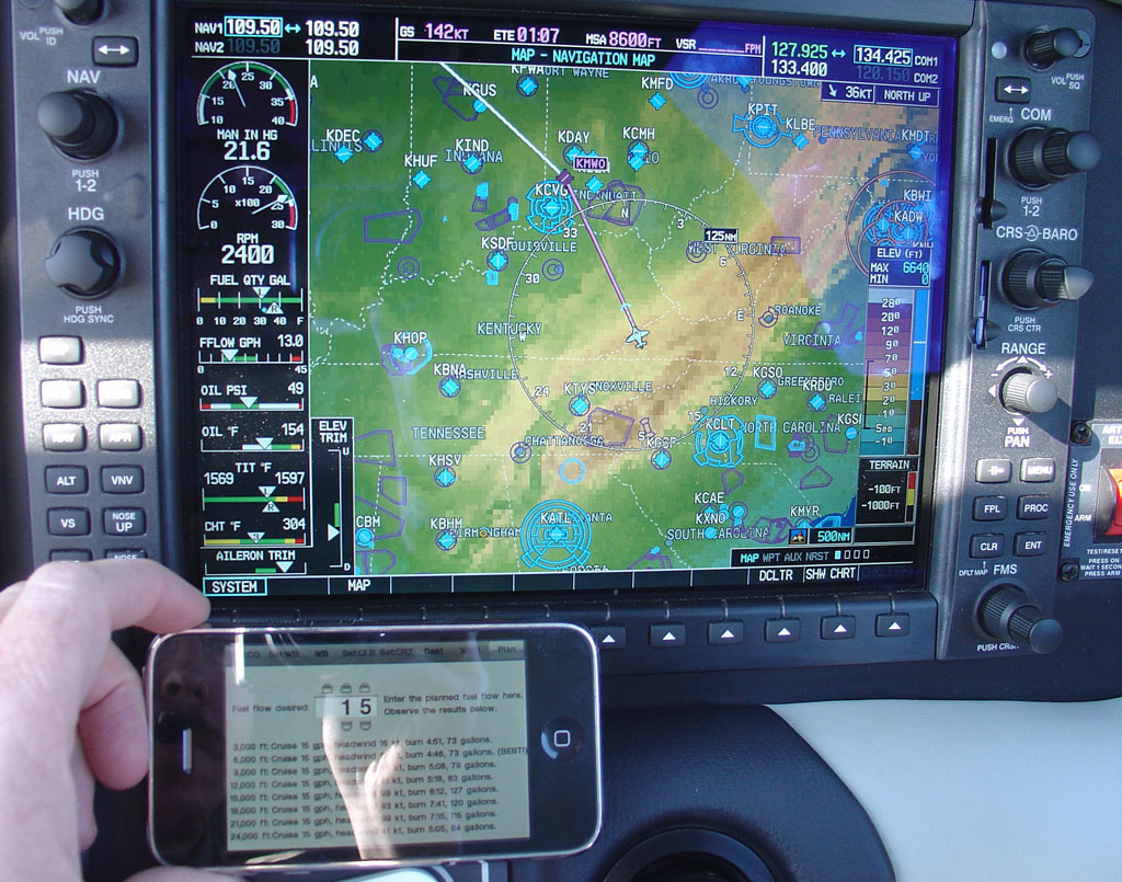
Below: Garmin 1000 and iPhone.. you can go ANYWHERE with those! X-Planner gives 6,000 ft as the best altitude.
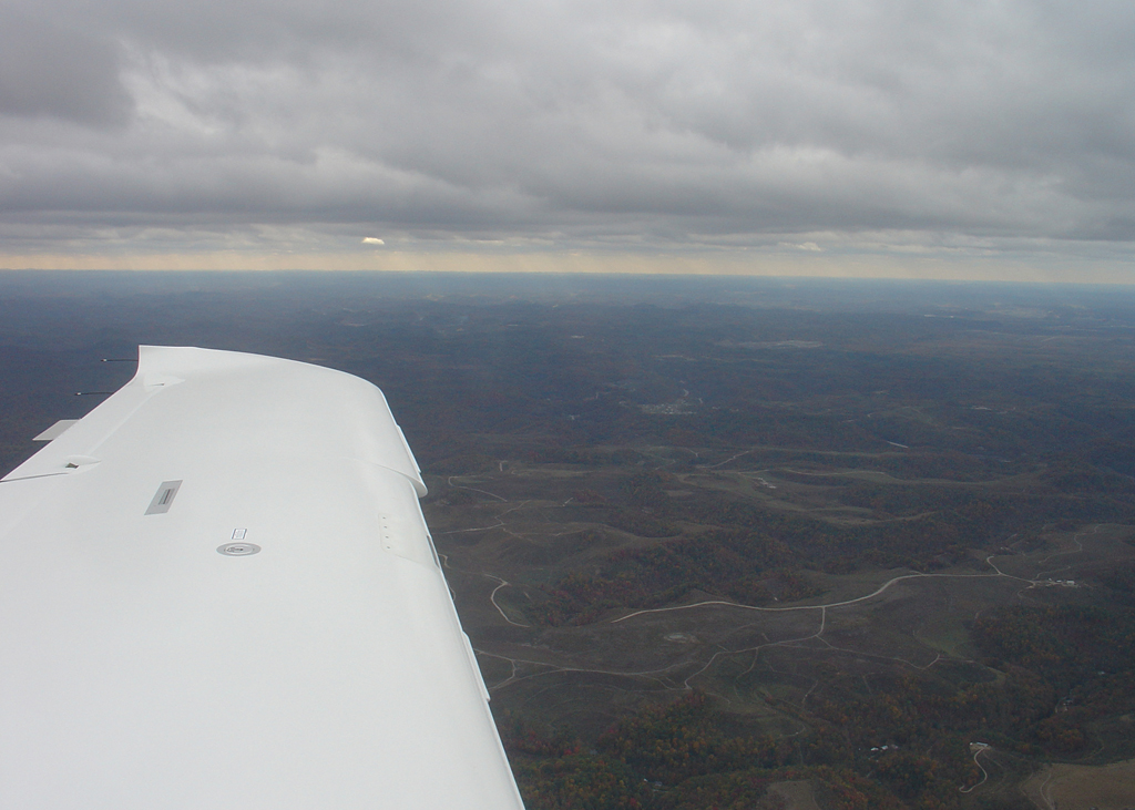
The view from down low at 6,000 ft.. clear from South Carolinas to Green Bay Wisconsin!
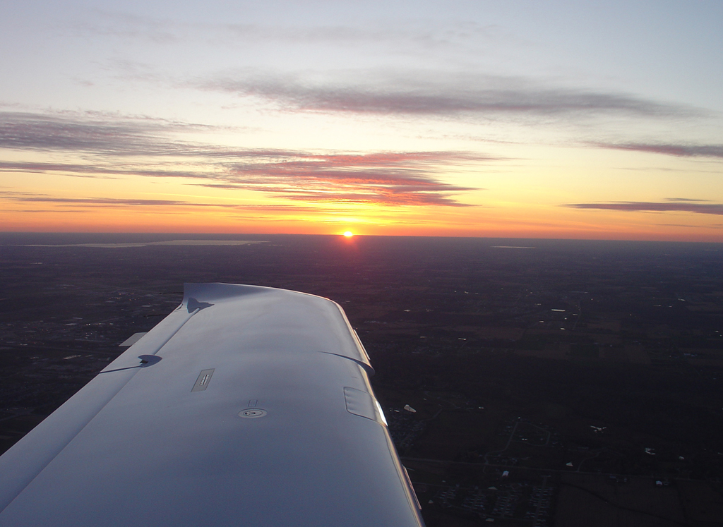
That last bit of sun on that flight… too bad the camera could not capture the dark clouds over the lake an hour later!